
Page 210
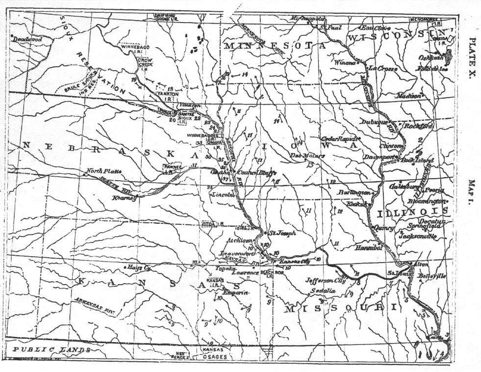
Map 1. Legend.— 1, Winnebago habitat; 2, Iowa habitat; 3, Arkansa habitat; 4, Kwapa habitat after leaving the Omahas, etc.; 5, Omaha habitat and route after separating from the Kwapas; 6, habitat at the mouth of the Missouri; 7, course along the river; 8, habitat at the mouth of the Osage river; 9, course of the osages; 10, course of the Kansas; 11, do. of the Ponkas and Omahas (Two Crows); 12, do. of do. (according to others); 13, meeting of Iowas, Ponkas, Omahas; 14, course of the three tribes; 15, Pipestone quarry; 16, cliffs about one hundred feet high on each bank; 17, fort built by the three tribes; 18, Lake Andes; 19, mouth of White River; 20, mouth of Niobrara river; 22, Bow creek (Omaha Village); 23, Ionia creek (Iowa Village); 24, Tʼi-tʼaⁿ-ga-jińga; 25, Large village; 26, village at Bell creek; 27, course of the Iowas; 28, Omaha habitat on the Salt river; 30, Ane nat'ai dhaⁿ; 31, Tʼacnańguji (Shell creek); 33, village on the Elkhorn creek; 35, village on Logan creek; 37, village at Bellevue.
Page 211
THE
AMERICAN NATURALIST.
Vol. XX. MARCH, 1886. No. 3.
MIGRATIONS OF SIOUAN TRIBES.1
BY REV. J. OWEN DORSEY.
"SIOUAN" is the term adopted by the Bureau of Ethnology instead of "Dakotan," as the name of the linguistic family of which the Sioux or Dakotas have been regarded as the leading nation.
The tribes whose migrations are described in this paper are the Ponkas, Omahas, Osages, Kansas, Kwapas, Iowas, Otos, Missouris, Winnebagos and Mandans. The other tribes of this family are the Sioux, Assiniboins, Hidatsas, Crows and Tutelos.
Some authors speak of a series of migrations of these tribes from the west toward the east, but the writer has not been able to learn on what authority such statements have been made, nor has he ever found any tradition of such eastward migrations among the tribes that he has visited.
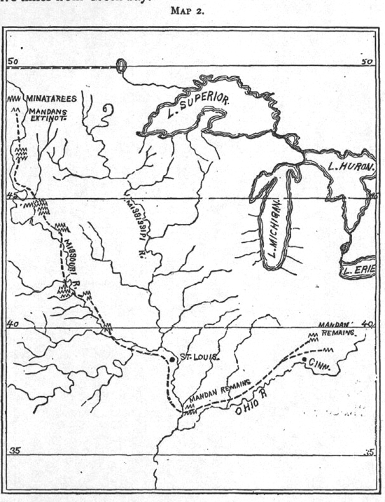
Whatever may be the value of Catlin's map of the Mandan migrations, there can be no doubt that the Mandans belong to the Siouan family. Their language shows unmistakable resemblances to the Winnebago, as well as to the Dakota, Osage, Kansas, etc. The Mandan tradition, as given to Catlin, placed the ancestors of that people east of the Mississippi river at an early day (Catlin's N.A. Indians, II, 259).2
The Jesuit Relation of 1640 speaks of the Dakotas and Assiniboins, placing them in the neighborhood of the Winnebagos. This last nation was probably in the region of Green bay in 1614,
![]()
Page 212
when Champlain met eight of their men. They are also mentioned in 1620. In 1680 Father Membre said that they were near the Kickapoos. In 1766 Carver found them about thirty-five miles from Green bay.
About three years ago the Iowa chiefs who visited Washington at that time told the writer that their people, the Otos, Missouris, Omahas and Ponkas once formed part of the Winnebago nation. In confirmation of this note are the following statements: (a)About the year 1848 Rev. Wm. Hamilton, missionary to the
![]()
Page 213
Iowas, learned that when they sung their mystic songs they used the Winnebago language. (b)A careful study of the languages
of the Iowas, Otos and Winnebagos shows that they are very closely related; indeed, time may prove the necessity of including them in one group instead of two. (c)We have the tradition given by the Prince of Nieu Wied on p.645 of his first volume (German edition). (d)Gallatin (Trans.Amer.Antiq.Soc., 1836, p.127) says that the Iowas, Otos, Missouris, Omahas and Ponkas have a tradition that, at a distant epoch, they, together with the Winnebagos, came from the north; that the Winnebagos stopped on the banks of Lake Michigan while the rest, continuing their course southerly, crossed the Mississippi river and occupied the places in which they were found by the Europeans. (e)There is a statement made in Maj. Long's account of his expedition to the Rocky mountains, 1819 (ed. by James), of which the substance is now given: "The parent nation originally resided somewhere north of the great lakes. On moving southward a large body seceded, staying on the shore of a lake; these became the Ho-chan-ga-ra or Winnebagos. Another band separated from the main body on reaching the Mississippi—these became the Iowas (Pa-kho-che). At the mouth of the Missouri another band stopped and made a village, hence their name, "Ne-o-ta-che" (Ni-u-t'a-chi), now called Missouris. The Otos (Wa-to-ta, lovers of sexual pleasure) left the nation on the Mississippi (according to another account they seceded from the Missouris at the mouth of the Missouri river) and went across the country till they struck the Missouri near the mouth of the Great Nemaha. Here they remained a long time. Thence they went up to the Platte, and after hunting for some time near its mouth they moved further up the Missouri and built a village on the right bank of that river, about fourteen miles below Council Bluffs, Ia. While they were there a band of Iowas established themselves on the bank of the river, nearly opposite to them and within thirty miles of the site of the Omaha village, in 1819. The Otos subsequently removed to the Platte, about twenty miles above the village occupied by them in 1819, but finding the latter situation a better one, they established themselves there (about A.D. 1769)."
"The Iowas, after remaining in a village on the Lower Missouri for a long time, were rejoined by the band above mentioned, when they returned to the Mississippi and erected a village on the Moyene."
Page 214
This must refer to a late period in the history of the Iowas, extending back, perhaps, not further than 1740 or 1750. This will appear the more plainly after comparing the above statement respecting the Otos with the map of the migrations of the Iowas given as Plate XXX in Vol. III of Schoolcraft's Archives of Aboriginal Knowledge. A copy of the map accompanies this article. The supposition of the writer is also in accordance with what follows about the migrations of the Iowas in company with the Omahas and Ponkas.
"The Missouris in course of time abandoned their village at the mouth of the Missouri, and gradually ascending the river at length built a town on the left bank, near the mouth of Grand river. They were found there by the French, who built a fort on an island in the Missouri, very near them, about the beginning of the last century. * * * The Missouris continued to dwell in the same locality until, about twenty years since (A. D. 1798, 1799 or 1800), they were conquered and dispersed by a combination of the Saks, Foxes and some other Indians. Five or six lodges joined the Osages, two or three took refuge with the Kansas, and the chief part of the remainder amalgamated with the Otos."
In 1673 the Otos were placed by Marquette 1 between 40℃ and 41℃ N. lat., west of the Missouri and Mississippi rivers, east of the Maha (Omahas) and south-east of the Pana (Ponkas ?). The Iowas, according to the same authority, were between 40℃ and 41℃ N. lat., north-west of the Maha and west of the Pana. In 1680 the Ainoves (Iowas) were east of the Mississippi and near the Kickapoos, according to Membre (see Shea's Discov. and Expl. Miss. Valley, p.150). The Otos were "one hundred and thirty leagues from the Illinois, almost opposite the mouth of the Miskoncing." In 1687 the Otos were on the Osage river. In 1700 Iberville said that the Otos and Iowas were with the Omahas between the Missouri and Mississippi rivers, about a hundred leagues from the Illinois. In 1721 the Iowas were east of the Missouri river, above the Otos and below the Pawnees, being allies and neighbors of the Dakotas. The Otos were below the Iowas and above the Kansas, on the west side of the Missouri (Charlevoix, Histor. Journal, p. 294).
The Ponkas told Rev. A. L. Riggs that their ancestors used to dwell east of the Mississippi. They subsequently inhabited the
Back to reference
![]()
Page 215
country on the north side of the Missouri river, near its mouth. The Kansas and the Osages were the first to depart; then the Omahas and Ponkas followed the course of the Missouri towards its head. Mr. Riggs also says that the Ponkas went to the region of the Black hills, and were there before the Crows; but the Ponkas told the writer that the Crows inhabited that country and were owners of the Black hills when their ancestors arrived there, at which time there were no Dakotas in that region. This last statement is confirmed by the Dakota winter-counts in Dr. Corbusier's collection. The writer was also told that the Ponkas used to dwell north-east of the old Ponka reservation (which is in Todd county, Neb.), in a land where they wore snow-shoes. Since 1879 the writer has gained more definite information from other Ponkas, as well as from Omahas, Osages and Kansas, and it is now given.
Ages ago the ancestors of the Omahas, Ponkas, Osages, Kansas, Kwapas, Winnebagos, Pawnee Loups (Skidi) and Rees, dwelt east of the Mississippi. They were not all in one region, but they were allies, and their general course was westward. They drove other tribes before them. Five of these peoples, the Omahas, Ponkas, Osages, Kansas and Kwapas, were then together as one nation. They were called Arkansa or Alkansa by the Illinois tribes, and they dwelt near the Ohio river. At the mouth of the Ohio a separation occurred. Some went down the Mississippi, hence arose their name, "U-ga'-qpa (Oo-ga-khpa)" or Kwapa (Quapaw), meaning "the down-stream people." This was prior to 1540, when De Soto met the Kwapas, who were then a distinct tribe.
The rest of the Arkansas ascended the river, taking the name of U-maⁿ'-haⁿ" (Omaha)," those going against the wind or current."
These names—Kwapa and Omaha—are of more recent origin than Kansas, Osage and Ponka. We find proofs of the antiquity of these three names in the names of gentes in these tribes. Thus among the Ponkas there is a Ponka gens (the Ma-kaⁿ), and an Osage gens (the Wa-ja-je). The Omahas have a Kansas gens (the Kʼaⁿ-ze). The Kansas have a Ponka gens (Cedar people), an Osage gens (Deer people), and a Kansas gens (Kʼaⁿ-ze, associated, as among the Omahas, with the winds). The Osages have a Kansas gens (Kaⁿ-se) and seven Osage (Wa-ɔa-ɔe) gentes, one
![]()
Page 216
of which is the Ponka (Paⁿ-Hka). The last is associated with the red cedar. If the true meanings of the three names have been preserved, they can be gained only in one way—by questioning members of the secret societies in the tribes.
The writer has been unable to find an Omaha gens, and the only Kwapa village (not a gens) is among the Kwapas.
Joutel names four Kwapa villages—Otsote, Thoriman, Tonginga and Cappa. The first village is called by other French writers, Otsotchave, or Otsotchoue, the third, Topinga (evidently a printer's error), and the fourth, Kapaha. According to Shea these divisions of the Arkansas are extinct, but the writer has been able to find members of them still existing. When he was at the Osage agency, Indian Terr., in 1883, he met three Kwapas. From two of them he gained the following: The first village is U-ga'-qpa-qti, real Kwapas (Cappa or Kapaha). The second is U-zu'-ti-u'-hi (Otsote), which may mean village along an uzu or lowland level containing trees here and there. The third is Ti'-u-a'-dʰmoddh;i-maⁿ' (Thoriman). The name of the fourth village could not be learned from the Kwapas; but Margry tells us that it meant "small village" in the Kwapa dialect. The writer finds that this would be expressed by Taⁿ'-maⁿ ji'-gă, with which compare Tonginga and Topinga. In July, 1687, according to Joutel, two of these villages were on the Arkansas river, and the others were on the Mississippi. A visit to the Kwapas might furnish the writer with their traditions, etc. Though they must have separated from the Ponkas more than three hundred years ago, the dialects are still so similar that the Kwapas met by the writer could understand him very easily when he spoke to them in Ponka.
The Omahas and their associates followed the course of the Mississippi till they reached the mouth of the Missouri, remaining for some time near the site of the present city of St. Louis. Then they ascended the Missouri to a place called Tce-dŭń'-ga a'-ja-be and Maⁿ'da-qpa'-yĕ by the Kansas, and Maⁿ'-tʼa-qpa'-dhĕ by the Osages. This was an extensive peninsula on the river, having a high mountain as a landmark.1
Page 217
by the Kansas during their wanderings, and there are traces of similar duplications among the Osages. Besides this the Omahas and Ponkas never accompanied the Kansas and Osages beyond the mouth of the Osage river, and the Kansas did not reach the vicinity of Napoleon for some time after the separation at the mouth of the Osage river.
Back to reference
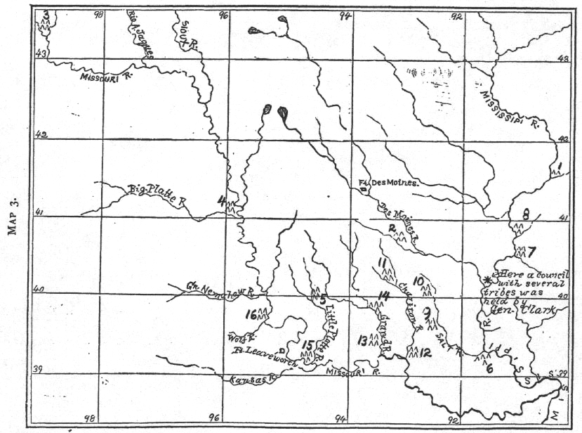
Map 3. Map of the country occupied by the Ioway tribe of Indian, from a map made by waw-non-qwe-skoon-a, an Ioway brave. Drawn by Capt. S. Eastman, U.S.A. (Plate XXX, Vol. III, P. 256, Archives of Aboriginal Knowledge, by H.R. Schoolcraft. No. 3, according to the Iowa Indian, was near the great pipstone quarry. The real place of the quarry was further east, at No. 15, of Map 1. It is very probable, that No. 3 of Map 3 was near the White River, Dakota, and if so, it may have been the same as No. 19 of Map 1.
Page 218
Here, according to the Kansas and Osages, the ancestors of the four tribes dwelt together. In the course of time they ascended the Missouri and established themselves at the mouth of the Osage river. The Iowas were near them; but the Omahas say that at that period they did not know the Otos and Missouris. At the mouth of the Osage river the final separation occurred. The Omahas and Ponkas crossed the Missouri, resuming their wanderings. The Osages ascended the stream bearing their name, and at a tributary, called by them "Tse'-tʼŭáⁿ-kʼa'-qa," they divided into the Pʼa-he'-tʼsi (those who camped at the top of the mountain), incorrectly styled Great Osages, and the Ü-tʼsĕH'-ta (those who camped at the base of the mountain), popularly called Little Osages. The Kansas ascended the Missouri on the south side till they reached the Kansas river. A brief halt was made, and the journey was resumed. They ascended the Missouri on the east side till they reached the present northern boundary of the State of Kansas. There they were attacked by the Cheyennes, and were compelled to retrace their steps. They settled again at the mouth of the Kansas, till the "Big Knives" came with gifts and induced them to go further west. Their subsequent history, as given to the writer by two chiefs, contains an account of about twenty villages along the Kansas river, then the settlement at Council Grove, Kas., and finally the removal to their reservation in Indian Terr.
Let us return to the Omahas and Ponkas. After crossing the Missouri they were joined by the Iowas, according to Two Crows and Joseph La Fleche, of the Omahas. They said that this addition to the party was made about the time of the separation from the Osages and Kansas. But the Iowa tradition, as given to Mr. Hamilton (see map of the Iowa brave) places the first village of that tribe west of the Mississippi, on the Des Moines river. The two Omahas just named said that their fathers followed the tributaries of the Missouri till they reached the great Pipestone quarry in Minnesota. Other Omahas have said that the course was up the Des Moines river, which would naturally bring the wanderers near the quarry. The writer is inclined to believe that they ascended the Chariton river, and when at its source they would be near the Des Moines. As the Iowas were a cognate tribe, it was reasonable for them to unite with the others. At all events the traditions agree in this: the people built earth lodges (perma-
![]()
Page 219
nent villages), they farmed and hunted the buffalo and other animals. When the game became scarce in their neighborhood, they abandoned their villages and went north-west. On reaching a place near the new haunts of the game, other permanent villages were built and they were occupied for years. So they lived till they reached the Pipestone quarry (which is not given in the right place on the Iowa map). When they arrived at the Big Sioux river they built a fort. At that time the Yankton Dakotas dwelt in a forest region of Minnesota, near the Mississippi, and were called "Jaⁿ'-a-tʼa ni'-ka-ciⁿ'-ga, people (dwelling) in the woods." By and by the Dakotas made war on the Omahas and their allies, defeating them and killing about a thousand warriors. This obliged the three tribes to abandon their habitat. They fled south-west till they reached the lake where the Omahas and Ponkas obtained their sacred pole. This is now called Lake Andes, and it is at the head of Choteau creek, Dakota. There the sacred pipes were given, according to the Omaha and Ponka traditions, and the present gentes were constituted. From this place they ascended the Missouri river till they reached White river (Ni-u' ga-cu'-de). There the Iowas and Omahas remained, but the Ponkas crossed the Missouri near the mouth of the White river, and went on to the Little Missouri river and the country near the Black hills. They subsequently rejoined their allies and all descended the Missouri on its right bank. When they reached the mouth of the Niobrara river the final separation was made. The Ponkas remained there. The Omahas settled on Bow creek, Neb., which they called "Village stream." The Iowas advanced to the stream on which is situated the town of Ionia, Dixon county, Neb., hence its name, "where the Iowas farmed." By and by the Omahas removed to a place near Covington, Neb., which is opposite Sioux City (see 24 on Map I). The remains of this village are known as Tʼi tʼań-ga jiń-ga, and the lake near by is called "Dhix-u-cpaⁿ-u-gdhe," because of the willows along its banks.
In the course of time the Iowas passed the Omahas again and made a village near the place where Florence, Neb., now stands. After that they continued southward till they reached their reservation at the Nebraska and Kansas line. The Otos were first met by the Omahas, according to Mr. La Fleche, in comparatively recent times on the Platte river.
Page 220
Subsequent Migrations of the Omahas.—After leaving Tʼi tʼań ga tʼań ga (No. 24), where the lodges were made of wood, they dwelt at Zande butʼa. This is south-east of Tʼi tʼańga jińga, and is the name of a stream as well as of a prominent bluff near by. This stream empties into Omaha creek near the town of Homer, Neb. After a great freshet the Omahas crossed Omaha creek and made a village at or near Omadi, which was called Large village, near Village stream (Omaha creek). See No. 25 on Map 1. This was a favorite resort, as we shall see. Thence they removed to Bell creek, on the west side of which they made a village (No. 26). Thence they went south to Salt creek, below Lincoln (No. 28). Thence they returned to Large village (No. 25). When they were there, Half-a-day, the aged historian of the tribe, was born. This was about A. D. 1800. Thence they removed to A-ne na-t'ai dhaⁿ, where the people perished in a prairie fire, a hill on the Elkhorn river (No. 30). They stayed there five years. Then they settled on Shell creek, which they called Tacnańguji (No. 31). After which they returned to Large village (No. 25). Leaving this again, they made a village on the Elkhorn, near Wisner (No. 33), about A. D. 1822–3. Half-a-day married when he was there. About A. D. 1832–3 they returned to Large village (No. 25). Joseph La Fleche remembers having been there at that time. About A. D. 1841 they removed to Tan-waⁿ jińga dhaⁿ, the Small village (No. 35), at the mouth of Logan creek, where they dwelt for two years. In 1843 they returned to Large village (No. 25), and in 1845 they made a village on the curvilinear top of a plateau, near Bellevue (No. 37). In 1855 they removed to their present reservation.
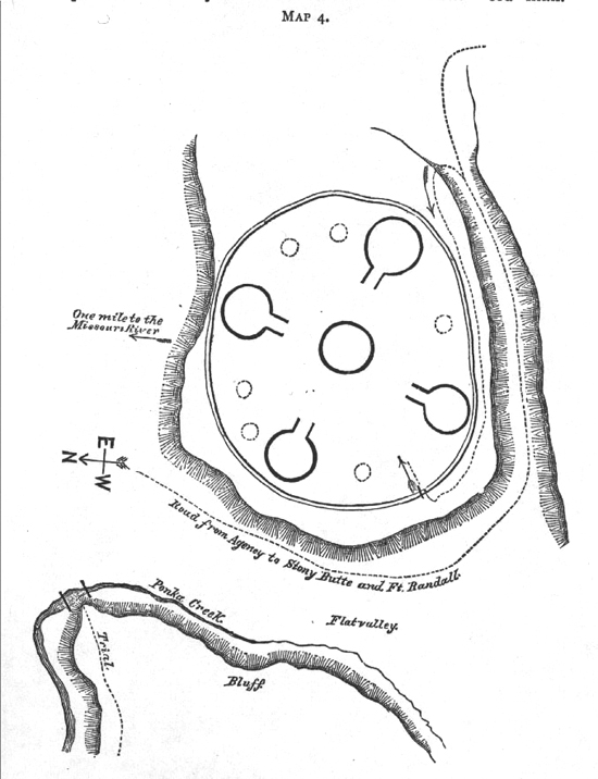
The Ponkas did not occupy their new country unmolested. They had some fights with the Cheyennes and Comanches. These foes dwelt near a great lake in a sandy region (Pʼi-za'-ba-he-he') near the head of the Elkhorn river, Neb. At this time the combatants used wooden darts instead of bows and arrows. The writer was at the old Ponka reservation, Todd county, Neb., from May, 1871, to Aug., 1873. During this period he often visited the remains of an ancient Ponka fort not more than a quarter of a mile from his house. A rough diagram of this fort is given.
After the Iowas and Omahas went south the Ponkas claimed all the northern part of Nebraska, along the Missouri river, as far as what is now Dakota county, where began the Omaha territory.
Page 221
The Ponkas say that they had seven "old men" since they became a separate tribe. Under the fifth "old man" they first saw the pale-faces. They are now under the seventh "old man."
The Omahas, according to some men of their tribe, are now under their fifth "old man." Among the Dakotas, according to some authorities, an "old man" denotes a cycle of seventy years
![]()
Page 222
or more. If the Ponkas use the term in this sense, and are correct in so doing, they may have had a tribal existence for about 490 or 500 years. This would extend back as far as A. D. 1390 or 1380. (It was told the writer in 1880.) Let us see how this agrees with the reports of early writers taken in connection with the period required for the migrations which have been described. We must remember that in those days firearms were unknown, and that therefore the destruction of game was not as rapid as it now is; that horses could not be had, rendering locomotion very slow; that removals from permanent villages (such removals depending on the destruction and departure of game) need not have been at very short intervals, especially when the construction of of such villages was a work of great labor, owing to the primitive character of the tools employed, and has a religious significance, being accompanied with sundry mystic rites, some of which are still preserved among the Osages and Kansas.
The director of the Bureau of Ethnology found a tradition among some of the civilized tribes in the Indian Territory, refering to the ancestors of the Kwapas, etc., which agrees with what has been said, i. e., that they dwelt east of the Mississippi prior to A. D. 1700. In 1673 Marquette had heard of the Maha (Omahas), Pana (Ponkas ?), Pahoutet (Iowas, Paqotce) and Otontantas (Otos), as inhabiting the country on the right bank of the Missouri river. The separation of the Iowas, Omahas and Ponkas, and therefore all previous migrations, must have occurred before 1673. Furthermore, the separation of the Kwapas from the others, and the taking of these correlative names, Kwapa and Omaha, must have occurred prior to A. D. 1540, as De Soto met the Kwapas in that year.
Even at the present day, when horses have been available, the Omahas have remained in a permanent village for ten years at a time, and have returned repeatedly to such an old village. We have no recorded tradition of similar returns to favorite villages in prehistoric times, yet such returns may have occurred, and if known would tend to increase the duration of the period between the meeting of the white men and the time when the Indians in question were east of the Mississippi river.
| More Omaha Heritage E-texts |