
| < Contents | Main Contents | THE STATE > |
Page 211
OMAHA SOCIOLOGY.
BY J. OWEN DORSEY.
CHAPTER I.
INTRODUCTION.
§ 1. The Omaha Indians belong to the C̸egiha groups of the Siouan family. The C̸egiha group may be divided into the Omaha-C̸egiha and the Kwapa-C̸egiha. In the former are four tribes, speaking three dialects, while the latter consists of one tripe, the Kwapas. The dialects are as follows; Pañka, spoken by the Ponkas and Omahas; Waɔaɔa, the Osage dialect; ʞaⁿze, that of the Kansas or Kaws, closely related to the Waɔaɔe; and Ugaqpa, or Kwapa.
§ 2. C̸egiha means, "Belonging to the people of this land," and answers to the Oto " ɔiwere," and the Iowa "ɔeʞiwere." Mr. Joseph La Flèche, who was formerly a head chief of the Omahas, also said that C̸egiha was about equivalent to "Dakota." When an Omaha was challenged in the dark, when on his own land, he generally replied, "I am a C̸egiha." So did a Ponka reply, under similar circumstances, when on his own land. But when challenged in the dark, when away from home, he was obliged to give the name of his tribe, saying, "I am an Omaha," or, "I am a Ponka," as the case might be.
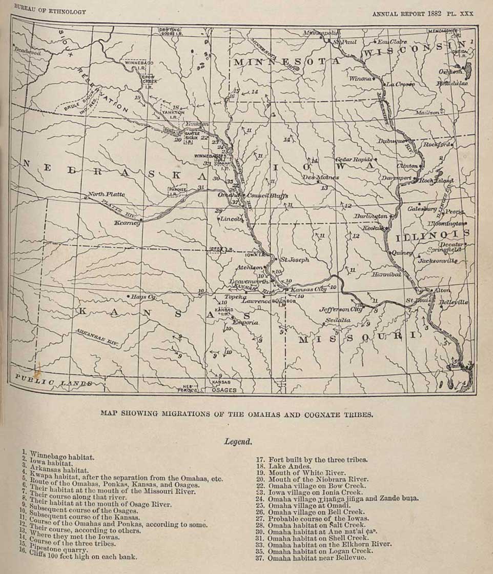
§ 3. The real name of the Omahas is "Umaⁿhaⁿ." It is explained by a tradition obtained from a few members of the tribe. When ancestors of the Omahas, Ponkas, Osages, and several other cognate tribes traveled down the Ohio to its mouth, they separated on reaching the Mississippi. Some when up the river, hence the name Umaⁿhaⁿ, from ʞĭmaⁿhaⁿ, "to go against the wind of stream." The rest went down the river, hence the name Ugáqpa or Kwápa, from ugáqpa or ugáha, "to float down the stream."
EARLY MIGRATIONS OF THE C̸EGIHA TRIBES
The tribes that went up the Mississippi were the Omahas, Ponkas, Osages, and Kansas. Some of the Omahas remember a tradition that their ancestors once dwelt at the place where Saint Louis now stands; and the Osages and Kansas say that they were all one people, inhabiting an extensive peninsula on the Missouri River.
Page 212
On this peninsula was a high mountain, which the Kansas called Maⁿ-daqpaye and Tce-dŭñga-ajabe; the corresponding Osage name be-Maⁿ-ʇaqpac̷ĕ.1
Subsequently, these tribes ranged through a territory, including Osage, Gasconade, and other adjacent counties of the State of Missouri, perhaps most of the country lying between the Mississippi and the Osage Rivers. The Iowas were near them; but the Omahas say that the Otos and Missouris were not known to them. The Iowa chiefs, however, have a tradition that the Otos were their kindred, and that both tribes, as well as the Omahas and Ponkas, were originally Winnebagos. A recent study of the dialects of the Osages, Kansas, and Kwapas discloses remarkable similarities which strengthen the supposition that the Iowas and Otos, as well as the Missouris, were of one stock.
At the mouth of the Osage River the final separation occured. The Omahas and Ponkas crossed the Missouri and, accompanied by the Iowas, proceeded by degrees through Missouri, Iowa, and Minnesota, till they reached the neighborhood of the Red Pipestone quarry. this must have take many years, as their course was marked by a succession of villages, consisting of earth lodges.
Thence they journeyed towards the Big Sioux River, where they made a fort. They remained in that country a long time, making earth lodges and cultivating fields. Game abounded. At that time the Yanktons dwelt in a densly wooded country near the head of the Mississippi; hence the Omahas called them, in those days, "Jaⁿ'aʇa ni'kaciⁿga, The people who dwelt in the woods." After that the Yanktons removed and became known as Yanktons. By and by the Dakotas made war on the three tribes, and many Omahas were killed by them. So as last the three tribes went west and southwest to a lake near the head of Choteau Creek, Dakota Territory, now known as Lake Andes (?). There they cut the sacred pole (see §§ 36 and 153), and assigned to each gens and subgens its peculiar customs, such as the sacred pipe, sacred tents, and the taboos. There were a great many gentes in each tribe at that time, far more than they have at present; and these gentes were in existence long before they cut the sacred pole.
After leaving the lake, known as "Waqc̷éxe gasai' c̷aⁿ, Where they cut the sacred pole," they traveled up the Missouri River till they arrived at Ni-úgacúde, White Earth River. They crossed the Missouri,
Back to reference
![]()
Page 213
above this and occupied the country between the Missouri and the Black Hills, though they did not go to the Black Hills.2 After awhile, they turned down stream, and kept together till they reached the mouth of the Niobrara, where the Ponkas stopped. The Omahas and Iowas continued their journey till they reached Bow Creek, Nebraska, where the Omahas made their village, the Iowas going beyond till they reached Ionia Creek, where they made a village on the east bank of the stream, near its mouth, and not far from the site of the present town of Ponca.
By and by the Omahas removed to a place near Covington, Nebr., nearly opposite the present Sioux City. The remains of this village are now known as "i-ʇañ'ga jiñ'ga," and the lake near by is called "C̸íxucpan-úgc̷e," because of the willow trees found along its banks.
In the course of time the Iowas passed the Omahas again, and made a new village near the place where Florence now stands. After that they continued their course southward to their present reservation.
The Otos did not accompany the Ponkas, Omahas, and Iowas, when they crossed the Missouri, and left the Osages and others. The Otos were first met on the Platte River, in comparatively modern times, according to Mr. La Flèche.
SUBSEQUENT MIGRATIONS OF THE OMAHAS.
§ 4. After leaving i-ʇañ'ga jiñ'ga, where the lodges were made of wood, they dwelt at Zandé búʇa.
2. Taⁿ'waⁿ-ʇañ'ga, The Large Village, is a place near the town of Omadi, Nebr. The stream was crossed, and the village made, after a freshet.
3. On the west side of Bell Creek, Nebraska.
4. Thence south to Salt Creek, above the site of Lincoln.
5. Then back to Taⁿwaⁿ-ʇañ'ga. While the people were there, Aⁿba-hebe, the tribal historian was born. This was over eighty years ago.
6. Thence they went to Áne-nát'ai c̷aⁿ, a hill on the west bank of the Elkhorn River, above West Point, and near Bismarck.
7. After five years they camped on the east bank of Shell Creek.
8. Then back to Taⁿwaⁿ-ʇañ'ga, on Omaha Creek.
9. Then on the Elkhorn, near Wisner, for ten years. While there, Aⁿba-hebe married.
10. About the year 1832–'3, they returned to Taⁿwaⁿ-ʇañ'ga, on Omaha Creek.
11. In 1841 they went to Taⁿ'waⁿ-jiñ'ga c̷aⁿ, The Little Village, at the mouth of Logan Creek, and on the east side.
Back to reference
Page 214
12. In 1843, they returned to Taⁿ'waⁿ-ʇañ'ga.
13. In 1845 they went to a plateau west of Bellevue. On the top of the plateau they built their earth lodges, while the agency was at Bellevue.
14. They removed to their present reserve in 1855.
PRESENT STATE OF THE OMAHAS.
§ 5. Their reservation was about 30 miles in extent from east to west, and 15 or 20 from north to south. It formed Black Bird County. The northern part of it containing some of the best of the timber lands, was ceded to the Winnebagos, when that tribe was settled in Nebraska, and is now in Dakota County. The southern part, the present Omaha reservation, is in Burt County. The Omahas have not decreased in population during the past twenty-five years. In 1876 they numbered 1,076. In 1882 there are about 1,100. Most of the men have been farmers since 1869; but some of them, under Mr. La Flèche, began to work for themselves as far back as 1855. Each man resides on his claim, for which he holds a patent given him by the Bureau of Indian Affairs. Many live in frame houses, the most of which were built at the expense of their occupants.
| < Contents | Main Contents | THE STATE > |